Fear Not the
Mountain-Passes; 13 days in the Sierras.
“Accidents in the
mountains are less common than in the lowlands, and these mountain mansions are
decent, delightful, even divine, places to die in, compared with the doleful
chambers of civilization. Few places in this world are more dangerous than
home. Fear not, therefore, to try the mountain-passes. They will kill care,
save you from deadly apathy, set you free, and call forth every faculty into
vigorous, enthusiastic action. Even the sick should try these so-called
dangerous passes, because for every unfortunate they kill, they cure a
thousand.” – John Muir.
Admittedly, the immensity of the distance to be traveled was
intimidating. Having never backpacked more than 4-5 nights, 50-ish miles in a
single trip before, the scope of the trip was daunting. This would be, at
minimum, a 162 mile hike, with no less than 35,000 feet of cumulative elevation
gain. We set aside for ourselves two weeks to complete it, allocating a little
under twelve miles per whole day of travel (first and last days are half days).
We arranged a shuttle from Tuolumne meadows, where we left
our car. The ride from our car to the trailhead at Onion Valley where we were
dropped off was about a three hour drive, mostly highway. Getting dropped off
this far from your car, knowing that the distance back would be traveled by foot through the mountains, carrying everything needed to survive on one's back is somewhat unnerving to say the least. As it turns
out, John Muir's words of wisdom proved true.
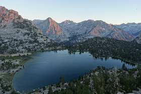
Day 1: Onion
Valley to Bullfrog Lake overlook. This
was our shortest, but heaviest day. We had seven days of food and supplies; 35 pounds in Lori’s Pack, a little under 50 pounds in Steve’s.
It is also a challenging start from an elevation standpoint, requiring a climb
to 11,700 feet in the first 5 miles. This is not the best way to approach high altitude hiking, which is ideally a more gradual one. It was also a half day. We ascended Kearsarge Pass in the afternoon, and found a dry site on a perch
above Bullfrog lake. The views were absolutely outstanding. 6.8 miles traveled/ elevation gain/loss in feet: +2800/-1000.
 |
| Above Bullfrog Lake |
 |
| Bullfrog Lake, at sunset, from camp |
 |
| Stars in the Sierra Nevada. These photos do little justice to the unbelievable vast density of stars observable night sky above 10,000 feet. |
 |
| The Milky Way was clearly visible as a swath of light, nightly. |
Day 2: Bullfrog
Lake to Woods Creek. On our second day, we climbed over one of the toughest (unbeknownst
to us at the outset) passes on the John Muir trail (according to the John Muir
Trail Survey results); Glen Pass (11,900 feet). We also traveled through Rae lakes, a beautiful,
albeit popular, section of the route. Further on, we traveled along the Woods
Creek drainage, past Arrowhead and Dollar Lakes, through subalpine meadows,
down in the forested canyon at the confluence of Woods Creek, over a sketchy
bridge, finishing up with a steep climb up the northern Woods Creek drainage,
camping at the confluence of White fork and Woods Creek. 14.6 miles traveled, elevation gain/loss in feet: +2400/-4200.
 |
| Surreal Unnamed lake below Glen Pass |
 |
| View South, observed from just below Glen Pass. Great Western Divide in the distance. |
 |
| Overlooking the Rae Lakes, view north from Glen Pass |
 |
| "Climb the mountains and get their good tidings". -John Muir. Rae Lakes. |
 |
| Arrowhead Meadow and Woods Creek |
 |
| Grouse |
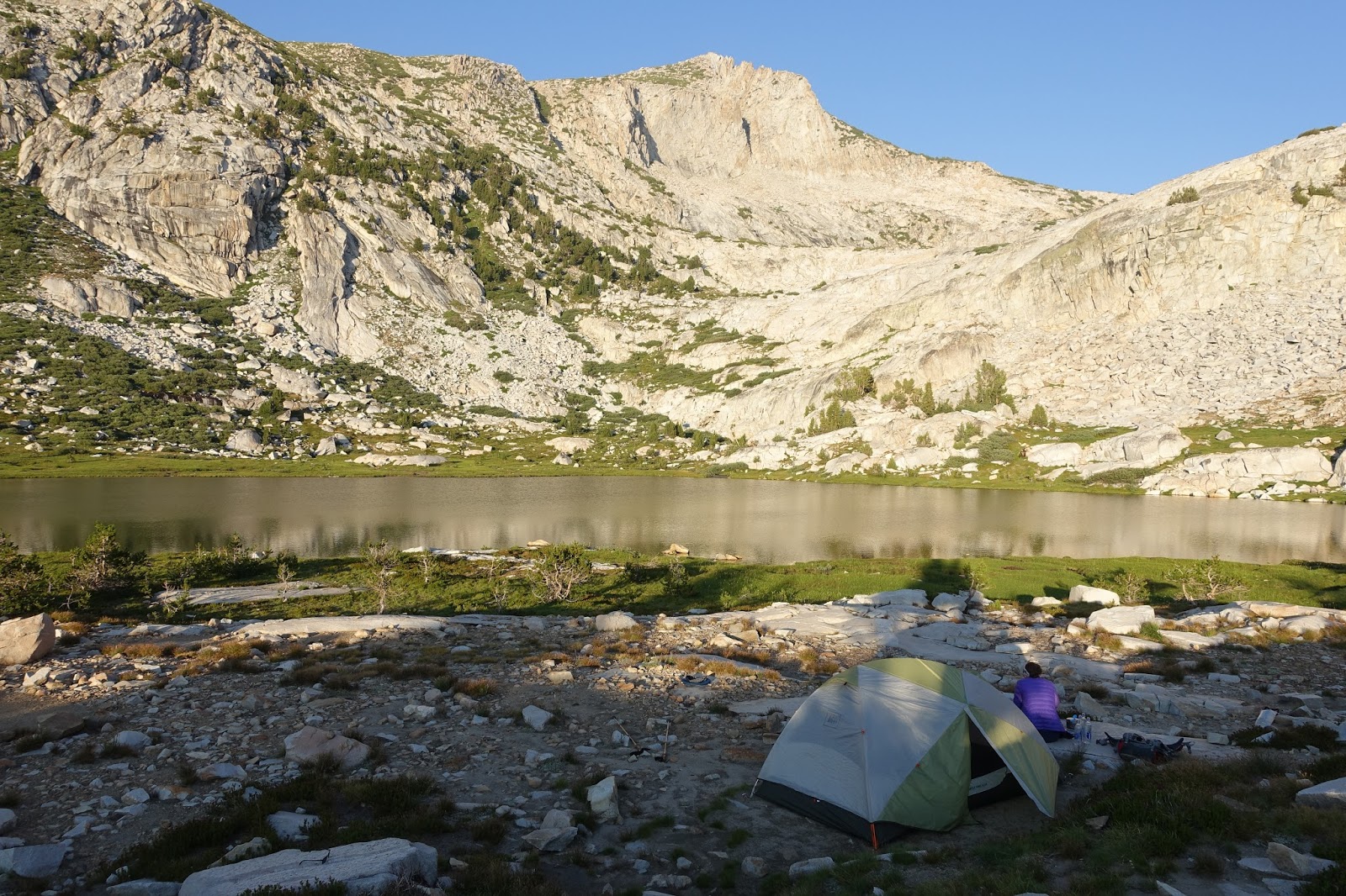
Day 3: Woods
Creek to alpine site 1 mile below Mather Pass. On our third day, we climbed up
beyond twin lakes, through an immense alpine landscape on our way to Pinchot
Pass. Then, we hiked down beyond lake Marjorie, crossing the South Fork of the
Kings River. The trail veers somewhat Northwest, were we made a gradual ascent
up to an alpine site below Mather Pass where we camped the third night. 15 miles traveled/ elevation gain/loss in feet: +5400/-3000.
 |
| Mt Wynne, on the way up Pinchot Pass |
 |
| Ascending Pinchot Pass |
 |
| Massive view southeast, Mt Cedric Wright in the center, viewed from Pinchot Pass |
 |
| View Northwest from Pinchot Pass, unnamed lake in the foreground, Lake Marjorie in the distance. The trail followed these lakes to the right, then turns to the West (left) to head toward Mather Pass. |
 |
| Alpine meadows, Below Mather Pass |
 |
| "Thousands of tired, nerve-shaken, over-civilized people are beginning to find out that going to the mountains is going home." -John Muir. Alpine camp, below mather pass, night three. Elevation: 11,400 feet. |
Day 4: Over Mather
Pass, to Le Conte Canyon. On our fourth
day, we climbed the remaining ascent over Mather Pass, down through Palisades.
We later descended the Golden Staircase, traveling further down trough Le Conte
Canyon. We finished this day with a slight gradual climb, making our way up the
first part of the ascent to Muir Pass. We set up camp on a solitary site
overlooking Little Pete Meadow. 17.5 miles traveled. Elevation gain/loss in feet: +2900/-5300.
 |
| View North, from Mather Pass (12,100 feet), Palisade Peaks (all over 14,000 feet) in the distance, Palisade lakes below |
 |
| Beyond Palisade lakes, overlooking LeConte Canyon. Black divide in the distance. |
 |
| Camp, night 4, beyond LeConte Canyon, Little Pete Meadow and Palisades Peaks in the distance, looking south. |
Day 5: Le Conte
Canyon to Colby Meadow. On our fifth day, we hiked from Le Conte Canyon, along
the Kings River, through subalpine and alpine zones, beyond meadows and past
the immense alpine Helen Lake (11,600 feet), over Muir Pass. We descended
through the Evolution Basin, beyond Wanda, Sapphire, and Evolution Lake, on
into Evolution Canyon, to camp at Colby meadow. Miles traveled: 16.5. Elevation gain/loss in feet: +3500/-2700.
 |
| Monster |
 |
| Big Pete Meadow |
 |
| Where's Waldo? (hint: Waldo is a mule team stopping to acclimatize on the way up Muir Pass). Unnamed lake, below Muir Pass |
 |
| View North, from Muir Pass(11,955 feet). Lake MacDonald, Wanda in the distance. |
 |
| Goddard Divide towering above Wanda Lake, Evolution Basin |
 |
| Evolution Lake, about 30 minutes before a thunderstorm sent us scurrying down below the timberline |
Day 6: Colby
Meadow to Muir Trail Ranch. On our sixth day, we hiked mostly downhill, from
Colby Meadow, through McClure Meadow, through a slightly precarious evolution
creek crossing (just above-the-knee deep and quite wide), down the drainage following
the San Joaquin headwaters, down further to Muir Trail Ranch, a mule-supported
outpost where we had shipped ourselves our five gallon bucket of food and other
essentials. 13 miles traveled, 1600 feet elevation gain, 3600 feet elevation loss.
 |
| San Joaquin River Canyon |
Day 7: Muir Trail
Ranch to Bear Creek. We departed on our seventh day with the added weight of
our food resupply (about 30 pounds for Lori, 43 ish pounds for Steve), up
initially steep switchbacks from Muir Trail Ranch (7600 feet), through forest,
then subalpine landscape, complete with meadows, then more gradually,
eventually over the 10,800 foot Seldon Pass. After lunch there, we descended
beyond the alpine Marie Lake, then found camp at Bear Creek. 15 miles traveled, Elevation gain/loss in feet: +3700/-2400.
 |
| View north overlooking Marie Lake from Seldon Pass. We napped in our tent near Marie Lake while it rained. |
Day 8: Bear Creek
to Squaw Lake. This may have been the most arduous day. We first climbed 1000
feet of unexpected switchbacks from Bear Creek to Bear Ridge, only to descend
from 10,000 feet to 7,500 in a series of seemingly endless forested switchbacks
into Vermillion Valley. We crossed Mono Creek at the bottom, and climbed
steeply up toward Silver Pass, stopping to take a nap (slept nearly an hour, no
exaggeration). Later in the afternoon, we completed the steep climb up over
10,800 foot Silver Pass. We descended to find camp above Squaw Lake, a
beautiful alpine lake in a cirque on a formerly glaciated shelf. 15 miles traveled. Elevation gain/loss in feet: +4000/-3000.
 |
| Views of the Vermillion Cliffs, descending switchbacks into Vermillion Valley |
 |
| View North, overlooking Chief Lake, limited by smoke, from Silver Pass 10,900 feet. |
 |
| Descending Silver Pass, Squaw Lake in the distance. |
 |
| Camp, night 8, Squaw lake, 10,300 feet. |
Day 9: Squaw Lake
to Deer Creek. Our ninth day was characterized by an up and down landscape,
down to Tully Hole, then up switchbacks to lake Virginia. We made our way to
Purple Lake, where we had lunch and watched trout swirl around and feed. We then
made our way beyond the Duck Lake outlet, around a ridge above Cascade Valley,
to a grungy, noisy camp at Deer Creek. 15 miles traveled. Elevation Gain/Loss in Feet: +2500/-2500.
 |
| Tully Hole in the foreground, Silver Divide in the distance. |
 |
| Lake Virginia |
 |
| Duck Lake Outlet |
Day 10: Deer
Creek to Rosalie Lake. On our tenth day, we made our way down to Red’s Meadow,
where our second resupply, a hot shower, a store, and a restaurant featuring
ice cream and fountain soda welcomed us. We then made the hot, arid climb up
through Devils Postpile, eventually making our way to Rosalie Lake. 15 miles traveled. Elevation gain/loss in feet: +2700/-2500.
 |
| Burn area with expansive views as far as the Ritter Range, the southeastern boundary of southern Yosemite National Park. |
 |
| Devils Postpile |
Day 11: Rosalie
Lake to Donohue Pass. On our eleventh day, we climbed from Rosalie Lake, past
Shadow, Garnet, Ruby, and Thousand Island lake, with the still somewhat
glaciated Ritter Range in the backdrop. We made our way up over the diminutive
island pass, through our last alpine meadow shrouded ascent, up over Donohue
pass, into Yosemite National Park. We found camp at an alpine site between two
gigantic rocks, with views of Mount Maclure an Mount Lyell, and the Maclure and
Lyell Glaciers to the north. To the south, we enjoyed sunset views overlooking
the immense meadows and oxbow drainage of Lyell Canyon. 16.5 miles traveled. Elevation gain/loss +3900/-2600.
 |
| Rosalie Lake, morning light |
 |
| Garnet Lake, the still-glaciated Mount Ritter in the background |
 |
| Glacier still hang on in cirques surrounding the 13,100 foot imposing Mt. Ritter. We first viewed the distant profile two days prior, from Silver Pass |
 |
| Emerald Lake |
 |
| Thousand Island Lake |
 |
| Where's Waldo? Waldo is a marmot who resides in the alpine meadows below Donohue Pass |
 |
| View East, from the ascent of Donohue Pass. |
 |
| View North, from Donohue Pass, 11,056 feet. Lyell Canyon in the Distance. |
 |
| Mount Lyell, Lyell Glacier, Mount Maclure and Maclure Glacier, viewed from camp on night 11. |
 |
| "How glorious the greeting the sun gives the mountains" - John Muir. Camp, night 11, overlooking Lyell Canyon, 10,600 feet. |
Day 12: Donohue Pass to Cathedral Lakes. On our eleventh day, we descended
from the alpine zone below Donohue Pass in to the seemingly endless meadows of
Lyell Canyon. Ahead on our itinerary, we opted to make the most of our rations
and permits by walking past our still parked car in Tuolumne meadows (actually
visible from the John Muir Trail), to Cathedral lakes. 19.2
miles traveled / elevation gain/loss in feet: +1700-3000.
 |
| Descending into the 12 mile long Lyell Canyon. |
 |
| Meadow, Lyell Canyon |
 |
| Cathedral Peak, viewed from camp night 12. |
Day 13: Cathedral
Lakes to Tuolumne Meadows. On this final day, we made our way down from the
glacial Cathedral Lake, retracing our path from the second half of the day
before back to our car. 7 miles traveled. Elevation gain/loss in feet: +500/-1200.
"Oh, these vast, calm, measureless mountain days, day in whose light everything seems equally divine, opening a thousand windows to show us God." -John Muir.
-----------------------------------------------------
Cost analysis: (see What Do You Really, Really Want? http://yourcameraisnotbigenough.blogspot.com/2016/03/what-do-you-really-really-really-want.html).
Wilderness Permit: $15 (plus, had to plan ahead and get up early to reserve). Shuttle: $280. Fuel: $230. Hotel (one night prior to starting in Independence, CA) $130. Food bucket shipping/storage: $125. Total Cost $780 for two weeks in the high Sierra. This does not deduct for the money not spent on incidental cost of American living (no eating out, no driving, AC, water use, etc for 14 days). If this was factored in, the cost of the trip would probably approach $0 but be difficult to calculate. The food eaten was likely cheaper than that eaten on a typical two week period (easy mac, almonds, snickers bars, etc.), but at a higher daily caloric intake (3,500-4000 calories per day), was probably a zero sum gain. The gear is a one time expense, so I didn't include it (nothing broke or wore out). The most significant cost was probably time preparing for logistics, resupply, permits, and physical training (many hours).


No comments:
Post a Comment