September 10, 2016:
The Arizona tundra calls. At 12,633 Humpherys is the tallest of the San Francisco peaks, and the highest natural location in the state of Arizona. After debating how to get ourselves up there, find a dog-sitter and book a hotel, we decided to just leave early on a Saturday morning, drive there, hike and drive home the same day.
 |
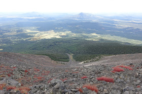
| The view southwest, ascending Humphreys, above the timberline |
The views from the ascent are spectacular and panoramic once the timberline opens up. To the north, I could see the North Rim of the Grand Canyon with its appreciably higher rim than the south rim.
Expecting this to be a pretty popular hike, we decided to keep count of the number of people we saw. We counted 165 going uphill, and we estimated that we saw about the same headed down. Overall it was about 350 people on the trail. A little much for me.
 |
| Humphreys Summit Flash Mob (Credit: Katy Clarke) |
It ended up being a 13 hour day, but way worth it. If we lived a little closer, we'd probably have left later in the afternoon for more of an evening hike. Or maybe a better weekday hike.
 |
| The view north, from Humphreys Peak, Grand Canyon north rim visible in the distance. (Photo badly lacks real -life clarity and vastness) |


An old tree runs down
ReplyDeleteTo every inch of ground
By an icy old stream
And nothing that's green can ever stand
Cool pictures. Do you ever use a peak finder app? I use one... called Peak Finder... which stores everything offline and works really well.
You got it buddy! I use Gaia GPS which lets you download different map layers and will place you on the map and record your route offline. I have had it fail a couple times, but for how much I use it, it has been a fairly good app. It is amusing, and fun to look back at a route after the fact. I still bring a paper map whenever I go somewhere that getting lost is a possibility.
ReplyDelete